Beek, I.J.M. van

Economic value of terrestrial ecosystems of Saba

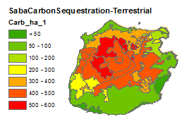
Map (GIS) showing the economic values of terrestrial ecosystems on Saba for:

  • Carbon sequestration
  • Cultural and local recreational value
  • Archeology

See this report for more information

For illustration, the excerpt below shows the carbon sequestration:


Date
2014
Data type
Maps and Charts
Theme
Research and monitoring
Geographic location
Saba

Economic value of marine ecosystems surrounding St. Eustatius

Map (GIS) showing the economic values of marine ecosystems on St.Eustatius for:

  • Carbon sequestration
  • Cultural and local recreational value
  • Fisheries
  • Tourism

See this report for more information

For illustration, the excerpt below shows the total economic value:

Date
2014
Data type
Maps and Charts
Theme
Research and monitoring
Geographic location
St. Eustatius

Economic value of terrestrial ecosystem on St. Eustatius

Map (GIS) showing the economic values of terrestrial ecosystems on St. Eustatius for:

  • Carbon sequestration
  • Cultural and local recreational value
  • Archeology

See this report for more info.

For illustration, the excerpt below shows the total economic value

Date
2014
Data type
Maps and Charts
Theme
Research and monitoring
Geographic location
St. Eustatius

Habitat diversity and biodiversity of the benthic seascapes of St. Eustatius

Quantitative habitat mapping and description form the basis for understanding the provisioning of ecosystem services and habitat connectivity, and hence provide an essential underpinning for marine spatial planning, management and conservation. Based on 869 video stations in a 150 x 200 m grid, we mapped 25.3 km2 of the near-shore island shelf of St. Eustatius at depths ranging 5-30 m. This yielded a coarse-grained map of the principal habitat classes of St. Eustatius’ seascapes. A total of nine principal seafloor habitats were distinguished. Gorgonian reefs amounted to 22% of the Statia Marine Park habitats sampled and were concentrated in the shallow wave-exposed eastern parts of the island (7.7 m average depths). The densest coral “scapes” and seagrass beds of St. Eustatius were concentrated at depths of about 24 m and only amounted to 4 and 5 percent resp. of the island shelf habitats studied. Whereas coral areas were essentially limited to the southern and south-western island shelf areas, seagrass beds were confined to the northern island shelf area. Including patch reef habitats, total hard coral-scape habitat for the St. Eustatius Marine Park amounted to about 19% of the area surveyed and about 475 ha of habitat. Sargassum reef habitat typically occurred at the seaward edge of communities dominated by hard coral growth.

Date
2014
Data type
Research report
Theme
Research and monitoring
Report number
C078/14
Geographic location
St. Eustatius

Saba Bank Research Expedition 2013 - Progress Report

The Saba Bank is the largest submerged carbonate platform of 2,200 km2 in the Caribbean Sea, which lies partially within the Exclusive Economic Zone of the Netherlands and partially within the territorial waters of Saba and St. Eustatius. The Saba Bank houses an expansive coral reef ecosystem with a rich diversity of species and as such is also an important source of commercial fish for the nearby islands.

The Saba Bank furthermore forms the largest protected area of the Kingdom of the Netherlands, after the Dutch part of the Wadden Sea in Europe. It was declared a protected area by the Dutch Government in 2010 and has been registered as such in the Specially Protected Areas and Wildlife (SPAW) protocol of the Cartagena Convention for the Protection and Development of the Marine Environment of the Wider Caribbean. In 2012 it was internationally declared a Particularly Sensitive Sea Area (PSSA) by the International Maritime Organization (IMO) and an Ecological or Biological Significant Area (EBSA) by the Convention on Biological Diversity (CBD). As there are no large land masses nearby, the Saba Bank can be considered as relatively pristine and remote from human influences. Anthropogenic threats such as fisheries and environmental threats such as climate change, sea surface temperature increase and acidification, however, also threaten the Bank’s coral reefs.

As part of the Saba Bank research program 2011-2016, commissioned by the Dutch Ministry of Economic Affairs (EZ), expeditions to the Saba Bank were conducted in October 2011 and from 19 to 26 October 2013. The Saba Bank research program aims to obtain information on the biodiversity, ecological functioning and carrying capacity for commercial fisheries to facilitate sustainable management of the area. The expedition was funded by the Dutch Ministry of Economic Affairs and the World Wildlife Fund in the Netherlands.

The primary objectives of the 2011 and 2013 research expeditions were to collect data on benthic and reef fish communities, and on sponges and nutritional sources of the sponge community. Studies added to the 2013 expedition were research into the structural complexity of the reef; coral-algal interactions; and connectivity between populations. An international, multidisciplinary team of marine biologists investigated the coral reef structure as well as the spatial variation in species assemblages and population genetic connectivity of corals, algae, fish and sponges during eleven SCUBA dives at 20-30m depth.

During the expedition thirty-three 50m long transects resulted in more than 2000 images of the reef, and over 5000 fish counts of almost 100 fish species. A preliminary comparison with the data from 2011 gives the impression of a reduction in snappers, groupers and grunts, while there were noticeably more sharks. There were fewer algae on the Saba Bank than in 2011, possibly indicating a healthier reef, although there appeared to be a gradient of increasing algal cover towards the island of Saba. It seems unlikely that this is related to anthropogenic activities on the island, but more likely to natural causes.

An overview of collected data and preliminary results is given in this progress report. Further comparative analysis between the data collected in the 2011 and 2013 and further analysis between research components, e.g. between algal biomass, herbivorous fish biomass and nutrient levels, will be performed in 2014. This may give more information on the potential causes of the observed south-north algal gradient.

The expedition elicited large public interest and media coverage in both Dutch and Caribbean media (details provided in Appendix F). The work of the researchers, both above and under water, was also recorded on film as part of the documentary series Marine Life for Discovery Channel.

Date
2014
Data type
Research report
Theme
Research and monitoring
Report number
C086/14
Geographic location
Saba bank

Elasmobranchs in the Dutch Caribbean: current population status, fisheries and conservation

In the Dutch Caribbean EEZ, at least 27 elasmobranch species have been documented. Of these, 9 are listed as “critically endangered” and 8 as “near threatened” by the IUCN. Elasmobranchs are not a target fishery in the Dutch Caribbean, but do occur as bycatch in artisanal fisheries. Sharks are considered nuisance species by fishermen. Most sharks caught are not discarded, but consumed locally, used as bait, or (reportedly) killed and discarded at sea on the two islands where landing of sharks is illegal (Bonaire and St. Maarten). Based on recent data, published sport diver accounts, and anecdotal accounts, it is clear that shark populations in most areas of the Dutch Caribbean have been strongly depleted in the last half century.

Date
2012
Data type
Other resources
Theme
Research and monitoring
Geographic location
Aruba
Bonaire
Curacao
Saba
St. Eustatius
St. Maarten

Shark protection plan for the Dutch Caribbean EEZ

Summary:

Shark populations have steeply declined worldwide due to unsustainable overexploitation and in this the Caribbean region is no exception. Since the 1990s many initiatives have been developed to protect the most threatened species. Sharks play an important ecological role in tropical marine ecosystems and represent an important economic potential in the context of ecotourism. As the Netherlands has traditionally shown strong international leadership and commitment in biodiversity protection, a key ambition of the new Dutch Caribbean Nature Policy Plan 2013-2017, developed jointly with the Dutch Caribbean islands, is the effective implementation of shark protection.

This report provides the necessary review and background on which to base such an endeavour. In 2012 27 species of sharks and rays were documented to be present in a deskstudy by IMARES, and six other species were listed to be tentatively present according to the IUCN Shark Specialist Group. In 2013 three new species were documented in field surveys carried out by IMARES. For these species this report provides an overview of available scientific knowledge on life history characteristics, distribution, abundance and population status in the Caribbean. The life history characteristics of slow growth, late maturity and low fecundity make sharks very vulnerable to overfishing and reduce their ability to recover from past overfishing. Because of their life history characteristics and their coastal habitat use for specific life stages, destruction of their main habitats and nursery grounds also has a relatively large impact on shark populations.

The main threats to address in a shark protection plan are fishing mortality and habitat quality. Although directed shark fisheries are not occurring in the Dutch Caribbean, there are additional concerns to global shark populations, which are mixed-species fisheries, bycatch and Illegal, Unreported and Unregulated (IUU) fishing. Sharks do occur as bycatch in artisanal fisheries in the Dutch Caribbean and illegal fishing by foreign vessels also occurs occasionally.

Public environmental awareness and support for management measures are a key determinant for the successful implementation of a shark protection plan. As part of this research a questionnaire was distributed amongst three key coastal resource user groups: fishermen, sport divers and local residents. It appeared there was no consensus on the perception of the change in biodiversity and abundance of sharks and rays. However, a decisive majority of the respondents was in favour of shark protection and half of the fishers was in favour to manage bycatch. Respondents were asked to rank specific measures in order of importance. The most appreciated measure for fishermen was enforcement including meaningful penalties and the most appreciated measures for the other respondents were a ban on shark finning and landing of sharks, followed by enforcement and immediate release of bycatch. However, in the opinion of some fishermen sharks are considered a pest, which are not specifically targeted, but when caught are consumed or sold like any other fish. Awareness raising of especially fishermen and children was added by several divers and residents as an important additional protection measure.

Throughout the world, sharks are playing an increasingly important role in island economies as an important natural attraction for eco-based recreation and tourism. A recent study has shown that a single shark can represent an average touristic resource value of US$ 2.64 million. Consequently, shark protection is taking flight around the world, including the Caribbean. In the last 3 years the region has seen the implementation of shark National Plan Of Action (NPOA) in the Bahamas, Honduras and Venezuela. Because the most destructive industrial-scale fishery practices (directed shark fisheries, shark finning, long-lining and gillnetting) have never been important in the Dutch Caribbean, the development and effective implementation of a shark NPOA is much simpler than in most situations. The overall feasibility for successful shark conservation are high due to a number of other factors listed in this report. 

Worldwide the use of sanctuaries is the main conservation tool. We therefore propose the establishment of a shark sanctuary as the main cornerstone to a Dutch Caribbean shark NPOA. This report outlines the ecological arguments for the establishment of a shark NPOA and sanctuary(ies), as well as the typical issues that need to be addressed. Legal designation of a shark sanctuary would form the first and most important step which provides the framework for all broader (international cooperation) and in depth (knowledge and conservation development) initiatives. Once a sanctuary is established, the fuller implementation of a shark NPOA should be seen as a gradual process, involving development of knowledge, policy, rules and regulations, public and stakeholder participation. In this, the Netherlands would follow and importantly reinforce the efforts of other nations who have already established NPOAs based on shark sanctuaries within the region.

The most promising area for establishment of a shark sanctuary is the little-fished Saba Bank as this area of unique biodiversity has the best shark population status, has recently already acquired national protected status and an active management structure, as well as international status as an EBSA and PSSA including IMO anchoring prohibition. Furthermore, a shark sanctuary for this area could importantly reinforce government plans to locate the first (part) of a Dutch Caribbean Marine Mammals Sanctuary at the Saba Bank. The shark population present presents unique research opportunities that could also generate considerable economic spin-off for the islands in terms of scientific research and knowledge development.


Management Recommendations:

  • Develop a simple and holistic shark NPOA based importantly on the use of one (or more) shark sanctuaries
  • Set up a shark research program combining on the one hand low tech opportunistic approaches (allowing participation of stakeholder groups for awareness and community support) and on the other hand using high tech approaches (genetic, telemetry, video-monitoring) to allow thorough insights even though abundance may be low
  • Start actively participating in regional shark conservation and ecosystem initiatives and seek active collaboration with sister sanctuaries of the region (Venezuela, Honduras, Bahamas) 
Date
2014
Data type
Research report
Theme
Governance
Education and outreach
Legislation
Research and monitoring
Report number
C209/13
Geographic location
Aruba
Bonaire
Curacao
Saba
Saba bank
St. Eustatius
St. Maarten

Saba Bank research expedition 2011 – Progress Report

Abstract:

The Saba Bank is a large submerged carbonate platform of approximately 2,200 km2 in the Caribbean Sea which lies partially within the Exclusive Economic Zone of the Netherlands and partially within the territorial waters of Saba and St. Eustatius. It was declared a protected area by the Dutch Government on 15 December 2010 and has been registered as such in the Specially Protected Areas and Wildlife (SPAW) protocol of the Cartagena Convention for the Protection and Development of the Marine Environment of the Wider Caribbean. Applications for a Particularly Sensitive Sea Area (PSSA) at IMO and Ecological or Biological Significant Area (EBSA) at CBD are pending.

As part of the Saba Bank research program 2011-2016, commissioned by the Dutch Ministry of Economic Affairs (EZ), an expedition to the Saba Bank was conducted from 22 to 29 October 2011. The Saba Bank research program aims to obtain information on the biodiversity, key ecological processes and carrying capacity for commercial fisheries to facilitate sustainable management of the area. The primary objectives of the 2011 research expedition were to collect data on benthic and reef fish communities; sponges and nutritional sources of the sponge community; seabirds and marine mammals; water quality, water velocity and other physical parameters. A multidisciplinary team conducted video and visual surveys on benthos, fish and sponges during 10 SCUBA dives at 20-30m depth, while sea birds and marine mammals were surveyed by means of on-board visual surveys and acoustic data loggers. Water velocity and water quality were also measured on-board using an Acoustic Doppler Current Profiler (ADCP) and Conductivity, Temperature and Depth (CTD) device.

During the expedition 8 sponge species were collected and 37 scleractinian coral species and 85 fish species were identified.Fish biomass varied per site between 1.3 kg to 4.4 kg.
Part of the measurements on water velocity, water quality and benthic cover are still in the process of being analysed. Data collected will also be used as baseline for future monitoring and analyses of biodiversity and key ecological processes within the framework of the 2011-2016 research program. 

Date
2013
Data type
Research report
Theme
Research and monitoring
Report number
C018/13
Geographic location
Saba bank

Kennisvraag haaien: wat is er bekend over haaien voor de voor Nederland relevante gebieden?

Date
2012
Data type
Research report
Theme
Governance
Legislation
Geographic location
Aruba
Bonaire
Curacao
Saba
St. Eustatius
St. Maarten

Lobster trap detection at the Saba Bank

Abstract:

According to previous studies and anecdotal evidence there are a lot of lost lobster traps at the Saba Bank. One study estimated the loss to be between 210 and 795 lobster traps per year. The Saba Bank is an approximately 2,200 km2 submerged area and spiny lobster (Panulirus argus) is one of the main fisheries with an annual economic value over USD 1 million.

The traps get lost due to a combination of bad weather moving or damaging traps and marker buoy lines, ship traffic running into and cutting marker buoy lines and removal of marker buoy or theft of traps by vandals. Lost traps are a concern for the Saba Bank fisheries management, because of the potential impact of ghost fishing by lost traps and the damage to the benthic environment.

IMARES was commissioned by the Ministry of Economic Affairs, Agriculture and Innovation to advise on a method to detect lost lobster traps. The objective of this desk study was to provide information for the sustainable management of the lobster fisheries and the conservation of the Saba Bank.

In this report we investigate the most efficient method for the detection of lost lobster traps from a small vessel in water between 15 and 50 meter depth. We not only address methods for the location of traps, but also recommend methods for the retrieval of traps and measurement of ghost fishing.

Findings:

The main conclusion from this study is that side scan sonar in combination with a magnetometer is the best and most efficient method to locate and retrieve lost lobster traps.

Side scan sonar is recommended for two reasons:

  • The resolution of the images can be small enough to detect 1m2 traps, while the swath width and vessel speed are high enough to cover a reasonable area in an 8-hour survey day.
  • In general, the survey environment at the Saba Bank is suitable for side scan sonar, as most lobster traps are located on flat surfaces with substrate composed of hard bottom pavement, rubble or sediment.

A magnetometer is recommended in combination with a side scan sonar because acoustic shadowing can occur for lobster traps located at the edge of the lobster fishing grounds. A magnetometer will detect (partial) buried, damaged or overgrown traps that have lost their distinct rectangular shape necessary to accurately identify traps from the side scan images.

The three suggested methods for retrieval are:

  • Autonomous Underwater Vehicle (AUV)
  • Remotely Operated Vehicle (ROV)
  • Drop Camera

Management Recommendations:

Since it is not reasonable to survey the entire potential lobster fishing grounds of 1.850 km2, a pilot is recommended. The pilot can be accompanied by a cost benefit analysis to advise decision makers if the costs per trap retrieved do not exceed the benefits.

It is recommended to introduce a reporting and registration system on gear loss to collect more comprehensive data on gear lost, date, coordinates, depth (unless this can be easily retrieved from coordinates data) and reason for loss. This can be incorporated in an existing fisheries landings registration system. Data on gear loss not only provide useful information for curative measures such as trap detection. It also provides information for preventive measures, as a detailed understanding of why gear is lost is needed to take effective preventive measures. They can be split in measures to prevent loss and measures to prevent ghost fishing. One measure to prevent ghost fishing is already in place, which is the use of biodegradable escape panels in the lobster traps. However, this regulation of 1992 has not been implemented properly due to lack of enforcement and compliance

Date
2012
Data type
Research report
Theme
Research and monitoring
Report number
C091/12
Geographic location
Saba bank