Topography maps of Curacao
Submitted by Peter Verweij on Fri, 06/24/2016 - 13:16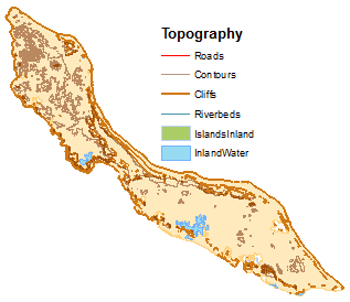
Multiple topographical map layers:
- Roads (source: CARMABI.)
- Contours (source: CARMABI)
- Cliffs (source: CARMABI)
- Inland island (source: CARMABI)
- Inland waterbodies(source: CARMABI)
- Riverbeds (source: derived from 30m digital elevation model (ASTER DEM)
Date
2011
Data type
Maps and Charts
Theme
Research and monitoring
Document
Geographic location
Curacao
