Duyl, F.C. van

Natural Diet of Coral-Excavating Sponges Consists Mainly of Dissolved Organic Carbon (DOC)

Abstract:

Coral-excavating sponges are the most important bioeroders on Caribbean reefs and increase in abundance throughout the region. This increase is commonly attributed to a concomitant increase in food availability due to eutrophication and pollution. We therefore investigated the uptake of organic matter by the two coral-excavating sponges Siphonodictyon sp. and Cliona delitrix and tested whether they are capable of consuming dissolved organic carbon (DOC) as part of their diet. A device for simultaneous sampling of water inhaled and exhaled by the sponges was used to directly measure the removal of DOC and bacteria in situ. During a single passage through their filtration system 14% and 13% respectively of the total organic carbon (TOC) in the inhaled water was removed by the sponges. 82% (Siphonodictyon sp.; mean6SD; 13617 mmol L21) and 76% (C. delitrix; 10612 mmol L21) of the carbon removed was taken up in form of DOC, whereas the remainder was taken up in the form of particulate organic carbon (POC; bacteria and phytoplankton) despite high bacteria retention efficiency (72615% and 87610%). Siphonodictyon sp. and C. delitrix removed DOC at a rate of 4616773 and 3546562 mmol C h21 respectively. Bacteria removal was 1.860.961010 and 1.760.661010 cells h21, which equals a carbon uptake of 46.0621.2 and 42.5614.0 mmol C h21 respectively. Therefore, DOC represents 83 and 81% of the TOC taken up by Siphonodictyon sp. and C. delitrix per hour. These findings suggest that similar to various reef sponges coral-excavating sponges also mainly rely on DOC to meet their carbon demand. We hypothesize that excavating sponges may also benefit from an increasing production of more labile algal-derived DOC (as compared to coral-derived DOC) on reefs as a result of the ongoing coral-algal phase shift. 

Date
2014
Data type
Scientific article
Theme
Research and monitoring
Journal
Geographic location
Curacao

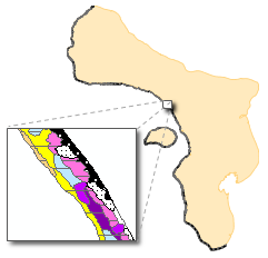
Living reef map of Bonaire

Living Reef map of Bonaire (GIS). Paper source from 1985. Scanned, geo-referenced and digitized in 2011-2012.

De oorspronkelijke atlas omvat een uitgebreide inventarisatie en kartering (schaal 1:4000) van de koraalriffen van Curacao en Bonaire. De kaartbladen zijn gedigitaliseerd (images) en voor deze kaart van Bonaire door Imares geplaatst op basis van de originele referentie UTM op internationale elipsoide (1924). Hierop zijn de herkenningen uitgevoerd en de ontstane shapes zijn daarna geprojecteerd naar WGS84_UTM_19n en verder bewerkt. De herkenning van de door kleur weergegeven types heeft plaatsgevonden met e-Cognitionper kaartblad, waarna alle bladen aan elkaar gekoppeld zijn. De toekenning van verschillende types en bedekkingsgraad is met de hand uitgevoerd. De toekenning van het kaartblad is gebeurd op basis van het laagste nummer waar een polygoon voorkomt.

Date
2012
Data type
Maps and Charts
Theme
Research and monitoring
Geographic location
Bonaire
Image

Towards a predictive model supporting coral reef management of Bonaire’s coral reef. Progress report 2012.

Date
2013
Data type
Research report
Theme
Governance
Research and monitoring
Report number
C070/13
Geographic location
Bonaire

Fast Detection of Nutrient Limitation in Macroalgae and Seagrass with Nutrient-Induced Fluorescence

Abstract:

Background: Rapid determination of which nutrients limit the primary production of macroalgae and seagrasses is vital for understanding the impacts of eutrophication on marine and freshwater ecosystems. However, current methods to assess nutrient limitation are often cumbersome and time consuming. For phytoplankton, a rapid method has been described based on short-term changes in chlorophyll fluorescence upon nutrient addition, also known as Nutrient-Induced Fluorescence Transients (NIFTs). Thus far, though, the NIFT technique was not well suited for macroalgae and seagrasses.

Methodology & Principal Findings: We developed a new experimental setup so that the NIFT technique can be used to assess nutrient limitation of benthic macroalgae and seagrasses. We first tested the applicability of the technique on sea lettuce (Ulva lactuca) cultured in the laboratory on nutrient-enriched medium without either nitrogen or phosphorus. Addition of the limiting nutrient resulted in a characteristic change in the fluorescence signal, whereas addition of non- limiting nutrients did not yield a response. Next, we applied the NIFT technique to field samples of the encrusting fan-leaf alga Lobophora variegata, one of the key algal species often involved in the degradation of coral reef ecosystems. The results pointed at co-limitation of L. variegata by phosphorus and nitrogen, although it responded more strongly to phosphate than to nitrate and ammonium addition. For turtle grass (Thalassia testudinum) we found the opposite result, with a stronger NIFT response to nitrate and ammonium than to phosphate.

Conclusions & Significance: Our extension of the NIFT technique offers an easy and fast method (30–60 min per sample) to determine nutrient limitation of macroalgae and seagrasses. We successfully applied this technique to macroalgae on coral reef ecosystems and to seagrass in a tropical inner bay, and foresee wider application to other aquatic plants, and to other marine and freshwater ecosystems. 

Date
2013
Data type
Scientific article
Theme
Research and monitoring
Journal
Geographic location
Curacao

Atlas of the Living Reefs of Curaçao and Bonaire (Netherlands Antilles)

The importance of reefs for man is multilateral and ranges from age-old functions, such as acting as a rampart preventing shore erosion, to modern mass tourism. Reefs offer man a source of income, actually providing subsistence for human populations. Food, often high quality protein , is the most important product . Reefs are also exploited for building material and for trade. Trade consists of living organisms such as aquarium fishes and other biota as shells, corals, etc. for jewelry and decoration purposes . A relatively new way of exploitation is by the tourist industry: snorkeling, diving and peripheral activities. Man grows more and more demanding in his use of the resources of the reef. Simultaneously, coastal development, urbanization and industrialization increase, obviously impairing reef communities . Reports on over-exploitation, pollution and mechanical destruction damaging reefs, are accumulating and show an increasing number of reefs suffering under the stress exerted on the shallow marine water habitat. Many reef areas are reported to deteriorate or be killed due to direct or indirect effects of tnan-induced disturbances

Opportunities for application of the atlas range widely in marine sciences, coastal planning and management. In the field of marine sciences the atlas will probably be most useful for studies in reef ecology, reef development, morphology and paleontology. Its value for coastal planning, management and conservation of the resources lies in immediate practical use.

This atlas contains 63 figures, 14 tables and 41 maps to give the reader an impression of what the coral reef ecosystems on the leeward coasts of Curaçao and Bonaire looked like in 1985. The leeward coasts of Curaçao (from Noordpunt to Oostpunt) and of Bonaire (from Malmok to the Willemstoren on the southern part) comprise approximately 66 resp. 56 km.

Precise habitat maps are drawn of this entire coastline and presented in fold-out maps in the back of the report.

[edit: a repetition of this study will presumably take place by Wageningen IMARES UR in the second half of 2013 to compare the two atlasses and pinpoint the changes that have occured over a little under 30 years.]

Date
1985
Data type
Research report
Theme
Research and monitoring
Report number
No. 117
Geographic location
Bonaire
Curacao