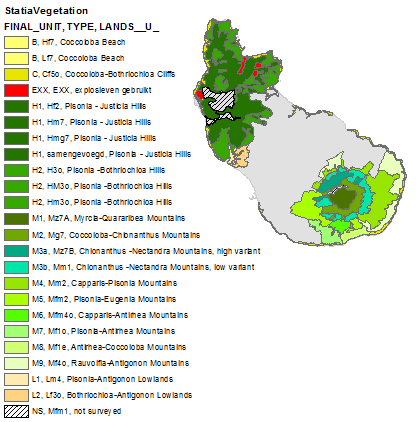
Vegetation map of St. Eustatius
A semi-detailed landscape-based vegetation map (GIS; scale: 1: 37,500) is presented for the 21 km2 Lesser Antillean island of St. Eustatius, Netherlands Caribbean. The principal lower sections of the island possesses a tropical savannah climate according to the KOPPEN (1931) classification system, and the documented flora amounts to 505 species. Color aerial photographs (1: 8,000) taken in 1991 were used to produce the map. A total of 84 vegetation sample plots were analyzed using a stratified random sampling design and TWINSPAN cluster analysis.A total of 13 semi-natural vegetation types and 16 different sublandscape types were distinguished based on different mixes and expressions of the component vegetation types.